Nearer to textbook, my Gibertini 1.5

Overall most transponders seem to up, but I have lost the the Africa beam transponder on 26.0°E also lost the mbc's they show signal, they just don't clear.

So my next job will be to try @moonbase method.
 
@Chris1979

Are you able to setup some type of laser pointing from the LNB to the dish to test if the LNB is aimed at the correct spot on the dish? I think there is a way to calculate the aiming point on the surface of an offset reflector? There have been a couple of topics lately on the forum that covered options for laser pointing to check if the LNB was aligned correctly, both "Blademedia" and "RimaNTSS" were reviewing laser pointing recently. I think "John" may also have used it in his Precision 2.2m install topic (would need to check to confirm)?


Rgds
 
Last edited:
I have thought about using a laser pointer, might have one kicking around somewhere.

Found out today my figures are a lot out, for example 3°w (zenith) 31.7° elevation.

According to the o.s. maps my magnetic declension angle is 6.7°

So I should be setting my polar mount to 31.4° & the dish face to 10.4°

That will give me better results. (Fingers crossed)
 
I have thought about using a laser pointer, might have one kicking around somewhere.
Found out today my figures are a lot out, for example 3°w (zenith) 31.7° elevation.
According to the o.s. maps my magnetic declension angle is 6.7°
So I should be setting my polar mount to 31.4° & the dish face to 10.4°
That will give me better results. (Fingers crossed)

@Chris1979

One method I have used in the past to get the dish/mount pointing at the zenith from my geographic location is to use the position of the sun and the shadow from a vertical feed support arm or vertical string on the face of the dish. The solar noon time in local time can be obtained for any geographic location and is a handy way to get the dish aligned to the zenith in the absence of a very close proximity satellite, depending of course on weather conditions.


Rgds
 
Chris, what calculations did you use?

I have never once aligned a dish using solar noon (citing the lack of sun!) and only roughly set the inclination/declination and then align on closest satellite and fine tune from there.

So, let's assume that my latitude is 51.4N and longitude 2.8W.

Am I correct in thinking that dish declination is 31.2 (3W) - 22.6 (CM offset angle) = 8.6 degrees?

And PM elevation is 90 - 51.4 = 38.6 degrees?
 
3°W is 31.6° elevation

So you would use this

(Sat elevation) + (declination) - (offset angle)

31.6°+ 6.8° - 22.6° = 15.8° dish face

31.6°+ 6.8° = 38.4° polar mount.
 
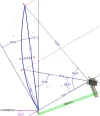
If 3*W has elevation 31.6* and antenna's offset angle is 22.6*, than antenna pointed to 3*W will have it's face leaning (correction) backwards 9* sharp. Simple like that. There is no need to take in account declination.
 
Last edited:
This drawing might help. If there is satellite with elevation 30* then CM antenna with offset angle 22.6* will have it's face leaning backwards 7,4*. I am not going to redraw this picture to nave satellite elevation 31.6*
 

Attachments

  • ScreenHunter_513 Oct. 23 20.52.webp
    ScreenHunter_513 Oct. 23 20.52.webp
    22.7 KB · Views: 12
...I have never once aligned a dish using solar noon (citing the lack of sun!)...

I have never once not aligned a motorised dish using solar noon, I just wait until the next time there is a shadow on the dish at the relevant time. The method is no good if the dish is required urgently or has to be installed on a fixed date, however, it is an accurate method to get the zenith position for a dish. I use the link below to get the solar noon time.

ESRL Global Monitoring Division - Global Radiation Group


Rgds
 
Back
Top
